Power to Visualize, Understand and Predict
Rothwell’s Paleo products form a robust suite of first-pass plate tectonics reconstruction and climate modeling tools that enable exploration geologists and GIS professionals to dynamically visualize, characterize and understand basin and play development.
In an ever-accelerating global race to discover hydrocarbon and mineral analogues and evaluate new lease tracks, plate tectonics and paleoclimate analysis provide essential insight into the evolution of organic deposits and source rock formation over time, which has become an important component of the exploration industry’s screening workflow.
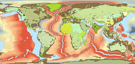
Coupled with other critical Earth and carbonate process information, paleo plate tectonics and climatology deliver valuable business intelligence that improves the accuracy of depository analysis, empowering explorers to make decisions faster, with less risk and lower field appraisal costs.
Today, the majority of global and emerging exploration and production companies leverage these tools as part of their exploration analysis workflow. Learn more at PaleoGIS.com
PaleoGIS is built on the industry-leading Esri ArcGIS platform and is provided as a fully integrated extension.
Previously, exploration scientists had to painstakingly create plate reconstruction maps by hand or rely on published research. Even with GIS tools, incorporating the vast amounts of available data is still a mammoth and time consuming task. Furthermore, these static maps offer no capabilities to dynamically test and validate assumptions, integrate proprietary data or precisely manipulate the historical time perspective, all of which are vital activities for determining formation or enrichment potential. … Learn more about PaleoGIS
Add paleo-geologic analysis to academic research. Share powerful analysis with student communities.
PaleoWeb is a hosted plate tectonics reconstruction application, powered by open-source technologies and designed for geology, geoscience and life science academic and research communities. PaleoWeb’s first release includes the majority of functionality from Rothwell’s flagship plate tectonics reconstruction modeling application, PaleoGIS. Additional functionality is to be added over time. … Learn more about PaleoWeb
The power of paleoclimate modeling is now at your fingertips.
PaleoClimate™ is a desktop application that employs a parametric approach to model the climate of ancient Earth. The product uses paleogeographic data as inputs for calculating all paleoclimate outputs. The elevation and distribution of land and sea for a given time is used to predict surface-level pressure, which is then used to compute all other outputs, including sea-level temperature, surface temperature, wind direction and azimuth, ocean currents, coastal upwelling and wetness. … Learn more about PaleoClimate™
Do more in less time. PaleoRun is a powerful utility that makes it possible.
Frequently, geoscientists and GIS professionals need to run a large number of reconstructions, animations or climate simulations. Or they need to kick off an extended analysis. This often occurs when their plate model vendor releases new data. Updating a library of reconstructions can be very time consuming. Now, users can create a single batch run that includes either PaleoGIS or PaleoClimate™, or both jobs. Jobs can be scheduled for regular intervals or overnight, or over the weekend if they are long running. … Learn more about PaleoRun
Leverage and share plate tectonics analysis directly from a web browser, without a working knowledge of ArcGIS.
PaleoGlobe was developed to extend the availability of plate tectonics modeling to a broader audience of exploration professionals. Plate tectonics has long been a viable yet cumbersome analysis methodology for assessing deposit potential. The challenge was placing plate tectonics in the hands of the geoscientist or asset analyst who was engaged in new lease assessments only periodically. An additional obstacle was the learning curve associated with mastering ArcGIS. … Learn more about PaleoGlobe
Execute real-time geologic searches across geologic time, geographic area and keywords.
The amount of data gathered and incorporated into basin and play development analysis continues to grow significantly, meaning the value of rapid data access and retrieval has never been greater. Rothwell’s PaleoSearch™ will allow geologists and GIS professionals to execute real-time geologic searches across geologic time, geographic area and keywords. PaleoSearch™ can be used with datasets that are either internally developed, purchased from third-party data vendors or compiled from public domain sources.
With PaleoSearch™, users will be able to quickly perform searches that can specify:
- A time interval of interest.
- A spatial area of interest (AOI).
- Multiple text filters to narrow down the search.
Further, the user can choose one or more dataset types to search with.
For example, a geoscientist may be interested in searching a geologic dataset for events that occurred on the East Coast of the United States during the time period of 210 Ma to 110 Ma. The user would submit the age range (210–110 Ma) and their geographic area of interest to PaleoSearch™. The user could also constrain the search with a text filter, such as source rock or igneous or rifting.
Traditionally, valuable data and specialized knowledge has resided within “siloed” groups or individuals. However, this same information could be leveraged throughout the organization. PaleoSearch™ will allow authorized users to rapidly search for and find any critical geologic data over a given time period, within a particular area of interest, thereby greatly enhancing the efficiency of their analysis projects.